Chattanooga launches a two-dock police drone-response program with a public dashboard
The city has published its dock locations, FAA radius, launch policy, privacy limits, evidence rules, training standard, and live activity data instead of stopping at a hardware announcement.
By Joel Kelly
Decision brief
Chattanooga has exposed more of the operating system than most DFR launches: where the aircraft sit, who can dispatch them, how far they can fly, how video is handled, how pilots train, and what the fleet has done. The next useful layer is outcome quality by call type, including cancellations, false deployments, complaints, and how often aerial information changed the ground response.
- Staged aircraft
- 2
- FAA radius
- 3 miles
- Dashboard snapshot
- 565 flights
BRINC Responders at two fire stations
Authorized operating radius from each dock
Program-reported total checked August 27
Operating model
The launch record names the aircraft, sites, remote crew, and FAA boundary.
The Chattanooga Police Department announced on August 26 that its Drone First Responder pilot is fully operational. Two BRINC Responder aircraft are staged at Chattanooga Fire Department Stations 4 and 9, with trained officers launching them remotely from the police Real Time Intelligence Center when a 911 or police-generated call meets the program criteria.
The city says the two dock locations were selected using violent-crime data and can be moved as that analysis changes. CPD has FAA authorization to operate the platforms within three miles of the docks. Once an aircraft reaches a call, it can stream live video to responding officers, remote operators, and incident commanders, then remain overhead until the call is stabilized. The department says the aircraft are not used for routine patrol or general surveillance.
Public record
A live dashboard makes the program easier to question and improve.
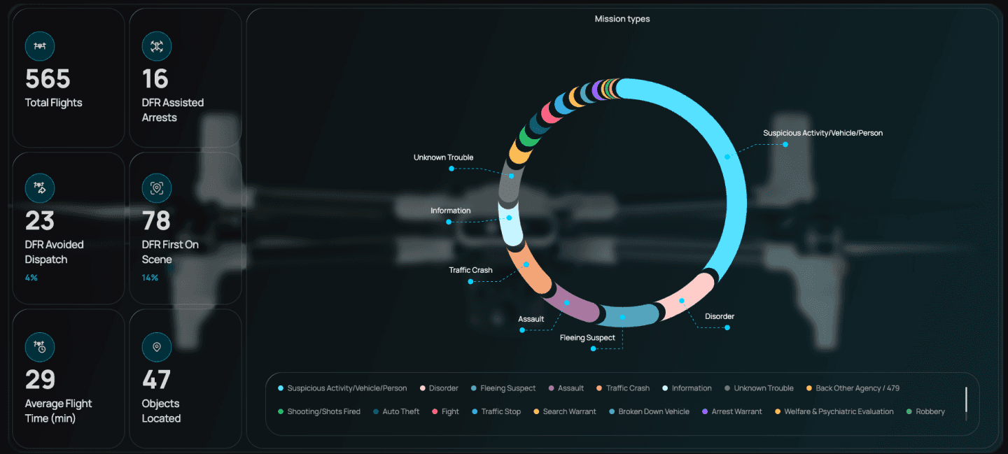
Chattanooga has also published a live activity dashboard rather than asking the public to judge the program from launch claims alone. When Drone Authority checked it on August 27, the dashboard displayed 565 total flights, 78 instances in which a DFR aircraft was first on scene, 23 dispatches avoided, 16 DFR-assisted arrests, 47 objects located, and a 29-minute average flight time. Those are program-reported counts, not an independent effectiveness study, and the live totals will continue to change.
The privacy and evidence rules are unusually visible for a launch announcement. CPD says the camera remains fixed on the horizon during transit, switches to overwatch at the call, and returns to the horizon for the flight home. DFR video is retained under the same policy framework as body-worn and in-car camera evidence. The department prohibits general surveillance, harassment, and non-law-enforcement use, while the public dashboard exposes flight maps, duration, call type, and date and time.
Minimum public record
What an accountable DFR program should publish
Hardware and a launch date do not establish public value. The operating record needs enough detail to test authority, use, privacy, reliability, and outcomes.
- 01
Define dispatch
Name the call types, decision maker, prohibited uses, camera posture, and conditions that stop a launch.
- 02
Show the authority
Publish the aircraft, dock sites, operating radius, FAA approval path, altitude, hours, and crew requirements.
- 03
Expose activity
Report flight maps, mission types, response times, cancellations, availability, dispatches avoided, and ground outcomes.
- 04
Audit the evidence
State who can view recordings, how long they are retained, how access is logged, and how complaints are reviewed.
Human system
Remote response still depends on trained operators and a measurable policy.
The program page also identifies the human requirement behind the dock. Operators must meet the applicable FAA COA, Part 107, or Part 91 conditions, complete department-approved basic and mission training, and participate in at least 16 hours of training each month. The city reports 13 certified drone operators across 21 aircraft in its wider UAS unit, while only the two BRINC Responders belong to this docked DFR pilot.
For another agency evaluating DFR, the Chattanooga record is useful because it makes the program auditable before claiming success. Dock locations, authority, dispatch criteria, aircraft, training, evidence retention, privacy limits, flight logs, and outcome counts can all be inspected. A stronger next version would add response-time distribution, calls cancelled after aerial review, weather and maintenance availability, complaints, data-access audits, and the ground outcome associated with each mission category.
Source file
Verify the reporting
Continue on Drone Authority
Put the report to work
Continue this beat
More public safety reporting
Industry · July 20, 2026
What BRINC's $125 million actually buys a 911 agency
Industry · July 28, 2026
An NYPD drone found six subway surfers, then had to hand them off to a ground team
Safety · October 8, 2026