Part 107 · Chart interpretation
Read a chart you haven't practiced before
Use a worked example, then answer ten questions with different FAA chart excerpts.
Open lesson and practiceRead the chart before choosing an answer
Practice finding evidence in an unfamiliar chart. You will read a boundary, put heights on the same basis, then check the airport or obstacle data. The ten questions use different excerpts from this worked example.
This is a visual chart task. Image descriptions identify the area; they do not reproduce every label. Use the enlarged chart's Actual size control to inspect small type.
1. Find the feature and follow its boundary
Locate the named airport or feature first. A city name can sit outside the area you need. Follow the boundary around the location rather than guessing from a nearby label.
2. Read the line style as well as its color
Class C uses solid magenta boundaries with Class C labels. Check the name and limits: a Mode C and ADS-B veil also uses a solid magenta line. Dashed blue marks Class D. Dashed magenta marks Class E at the surface. A fuzzy magenta edge marks a 700-foot above-ground floor.
3. Put both heights on the same basis
MSL means above mean sea level. AGL means above the ground. For a flight over level ground, add ground elevation in MSL to flight height in AGL. Class C labels show ceiling over floor in hundreds of feet MSL; SFC means surface. A boxed Class D ceiling is also in hundreds of feet MSL.
4. Keep airport and obstacle numbers separate
Blue airport data means a towered airport. Magenta airport data means an airport without a control tower. An airport block lists field elevation and runway data. An obstacle label gives its top in MSL, with its height above the ground in parentheses when shown. The large blue maximum elevation figure describes a whole chart quadrant.
- FAA Aeronautical Chart Users' Guide: airport data, Printed pages 14-16: Airports
- FAA Aeronautical Chart Users' Guide: obstacle heights, Printed page 11: man-made features and obstruction elevations
- FAA Aeronautical Chart Users' Guide: maximum elevation figures, Printed pages 12-13: Maximum Elevation Figure
5. Check what the excerpt cannot tell you
These dated crops test chart reading. They do not show every current operating condition. For a real flight, use current FAA charts, the Chart Supplement, current notices and the checks for the exact site. A correct height comparison alone does not approve a flight.
Separate a ceiling from an airport elevation
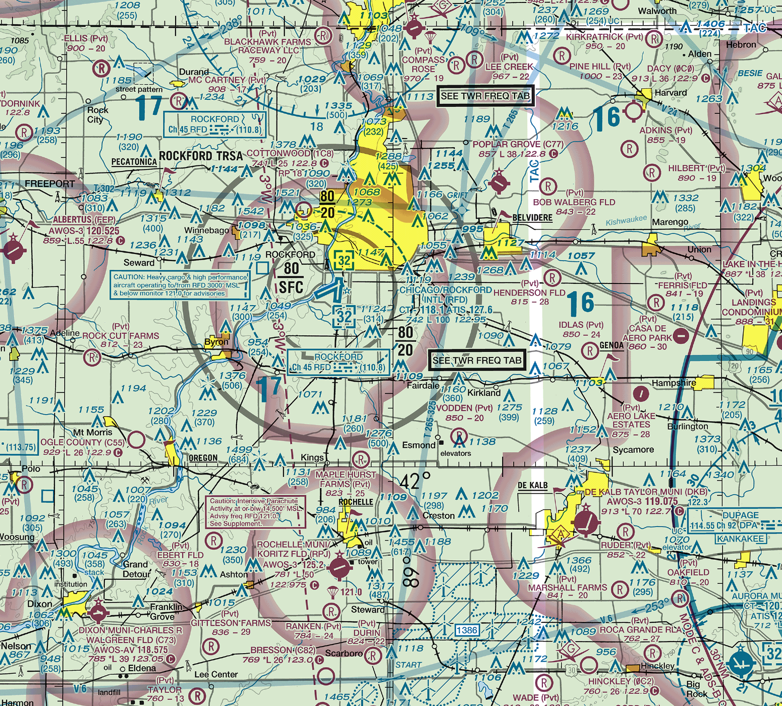
Rockford worked example
Separate lesson excerpt from the October 29, 2026 Chicago sectional. Training only.
Find Chicago/Rockford International (RFD). What does the boxed blue 32 mean? For this example only, use level ground at the airport's charted 742-foot elevation and a height of 300 feet AGL.
- Locate the RFD airport symbol and the dashed blue Class D boundary. The boxed 32 is the Class D ceiling label.
- Read 32 as 3,200 feet MSL. It is not a 3,200-foot height above the local ground.
- Read 742 in the airport block as the field elevation in feet MSL. The nearby L100 is runway lighting and length data, not an airspace limit.
- For the stated level-ground example, add 742 and 300. The resulting height is about 1,042 feet MSL, below 3,200 feet MSL.
The example height is below the depicted Class D ceiling. That comparison does not establish permission to fly. Ground elevation can change away from the airport, and a real flight needs the current airspace and operating checks.
- FAA Chicago Sectional Aeronautical Chart, Single-page chart; Milwaukee, Madison and Rockford excerpts
- FAA Aeronautical Chart Users' Guide: airport data, Printed pages 14-16: Airports
- FAA Aeronautical Chart Users' Guide: airspace, Printed pages 16-17 and 27: Controlled Airspace; Class D units; Mode C veil
- FAA Aeronautical Chart Users' Guide: keeping charts current, Printed pages 5-6: Introduction; Keep Your Charts Current
Apply the method to different charts
Select one answer for each question. You can change your choices before you finish. Explanations appear after you submit the full set.